


Class 5 Maths Chapter 8 Summary Notes PDF Download
Directions:
Direction is a way or path in which things move.
There are four cardinal directions.
For example, you are facing toward the East.
How to Find Directions?
We need a device called Compass, to find the Cardinal directions.
A compass is a device that helps to find directions.
It consists of a needle made of a magnet that always turns in the North direction.
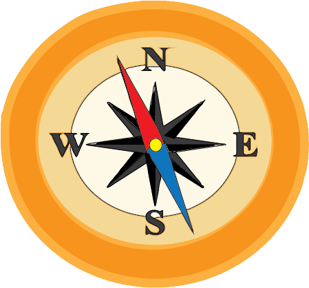
Compass
In the Compass image, ‘N’ stands for North, ‘S’ for South, ‘E’ for East and ‘W’ for West.
We know that the Sun rises in the East and sets in the West. Hence they are in opposite directions. Whereas North and South are opposite to each other.
From the Compass image, we can say that North is always in the right direction to the East and South is to the left.
Analyze the given image and answer the following questions.
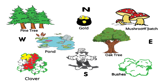
Directions of object
Solved example 1: The pond is in which direction of the oak tree?
Ans: The pond is located in the West direction.
Solved example 2: The gold pot is placed in which direction?
Ans: Gold pot is placed in the North direction.
Solved example 3: The direction that is opposite the pond is …
Ans: Pond is in the West direction hence the direction opposite to West is East.
Map Scale
Since it is difficult to add the exact distance on the map, we use a term called Scale.
In the image, it mentions that “1 cm = 2 km”, which means ‘1 cm’ on the map is equal to ‘2 km’ on the Earth.
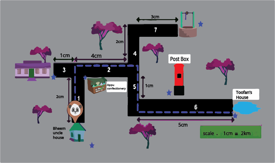
Map Scale
Now let us answer some questions with reference to the above image,
Solved example 1: What is the path taken by Panda?
Ans: The path chosen by Panda on the map is along 1, 2, 5, and 6. Panda starts at Bheem Uncle's house, then goes along with Appu Confectionery, then crosses Post Box and reaches Toofan’s house.
Solved example 2: Find the distance from Bheem's uncle's house to Toofan's house. (Hint: Distance is the length between two points.)
Ans: To find the distance, let us first add the total scale from Bheem's uncle's house to Toofan’s House. Follow paths 1, 2, 5, and 6 on the map.
2 cm + 4 cm + 1 cm + 5 cm
From the scale it is given that 1 cm = 2 km. Hence we should replace the 1 cm value with 2 km.
Hence we can write the scale values as
2 cm = 1 cm + 1 cm = 2 km + 2 km = 4 km
4 cm = 1 cm + 1 cm + 1 cm + 1 cm = 2 km + 2 km + 2 km + 2 km = 8 km
1 cm = 2 km
5 cm = 1 cm + 1 cm + 1 cm + 1 cm + 1 cm = 2 km + 2 km + 2 km + 2 km + 2 km = 10 km
Now let us add all the values,
4 km + 8 km + 2 km + 10 km
24 km
Solved example 3: From the map which is the longest road?
Ans: By looking at the map we can say that the largest scale number in the path chosen by Panda is the longest road. Hence 5 cm is the largest number, number 6 is the longest road.
Uses of Scale and Directions in Map
The scale is used in the maps to find the original distance between two places.
Whereas the directions help us to locate the place on a map.
Let’s solve some more examples by using scale.
Solved example 1: In a map, the scale is 1 cm of map = 5 km on Earth, then fill in the blank.
13 cm = ……….. km.
Ans: Follow the same method of the solved example given above,
1 cm = 5 km
13 cm = ? km
13 * 5 = 65 km
Solved example 2: From the image, the largest distance between A and B is in Map - 1 or Map - 2.
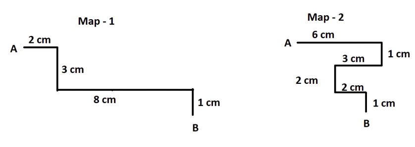
Distance between A and B
Ans: Let us first calculate the distance between A and B in Map - 1 and 2
Distance in Map - 1 = 2 cm + 3 cm + 8 cm + 1 cm = 14 cm
Distance in Map - 2 = 6 cm + 1 cm + 3 cm + 2 cm + 2 cm + 1 cm = 15 cm
Hence from both the distances, we can say that distance in Map - 2 is the largest.
Practise Questions
Q1. Answer the following questions, with reference to the map
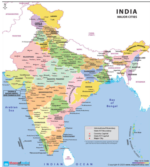
India Map
According to the map, the place that is located in the North is ………..
What is the direction of the Arabian Sea?
The Bay of Bengal is located in the East direction. True / False
Ans: We can solve these questions by placing the compass given in the image exactly placing it in the centre of the map.
New Delhi
West
True
Q2: The sun rises in the east. Hence north and south directions are in right and left of the east respectively. True / False
Ans: True
Importance of CBSE Class 5 Maths Chapter 8 Mapping Your Way
This chapter will teach you how to check a map and determine the distance using map scales. Maps are drawn following a scale. This scale can be used to interpret distance when the maps are accurate.
Learn how to check directions to reach a destination. You will also learn how roads, boundaries, and borders are depicted on a map. The chapter will teach you how to read maps and find distances between towns.
This chapter will help you depict the meaning of map scales and figure out how to solve the related problems given in the exercises. In fact, you will understand how to answer questions related to making it bigger and making it smaller by using map scales on your own.
Understanding a map will become easier when you learn the concepts in this chapter. Also, you will learn to match the map and the photo and extract proper information from the illustrations.
Benefits of Mapping Your Way Class 5 Worksheets and Revision Notes
Our subject experts have designed the revision notes based on the CBSE guidelines to ensure that the objectives of this chapter are preserved. Here is how you can benefit from the free PDF of revision notes and worksheets with answers.
The explanation of the concepts has been given in a simple way. You will understand the fundamental principles of recognizing map features quickly. You will comprehend the meaning of questions and answer them accurately.
As this is a new conceptual chapter introduced for the first time, focus on solving the exercise questions first. Solve and practice the Mapping Your Way Class 5 worksheets with answers. Compare your answers with the given solutions to check your answers. In this way, you will be able to identify if there are any errors in your solutions and prepare the chapter effectively.
Importance of NCERT Class 5 Maths Chapter 8 Mapping Your Way Revision Notes
The preparation of a chapter depends on the study material a student has organised. In the same context, NCERT Class 5 Maths Chapter 8 Mapping Your Way Revision Notes will become an integral part of the study material a student needs to understand the context and mathematical concepts of this chapter.
These notes focus on the CBSE Class 5 Maths syllabus and cover all the topics of this chapter skilfully. Students will find out the simpler version of the concepts and topics added to this chapter in these notes to complete preparing it well. They will find the highest convenience to use these notes and revise before an exam.
The easier version of the notes can be used to study this chapter well and recall what they have studied precisely during an exam. These organised notes will enable students to focus on how to use the concepts well to formulate the right answers to the fundamental questions.
CBSE Class 5 Maths Chapter 8 Mapping Your Way Notes can be accessed online or can be downloaded in PDF format for more convenience. You can access these notes offline or online according to your academic requirements and take your preparation to the next level.
Download NCERT Class 5 Maths Chapter 8 Mapping Your Way Notes PDF
Get the free PDF version of these notes and complete your study material for this chapter. Focus on the concepts and principles only by using these notes during revision. Complete revising this chapter efficiently and quickly and recall what you have studied by using the simpler version of these notes. Develop your concepts accordingly and learn how to score more in the exams by using these notes.
Add these revision notes to your study material for preparing this chapter and learn how to answer the given questions properly. Check how our subject experts have answered the questions and follow their answers to frame answers in your own words. Download these NCERT Class 5 Maths Chapter 8 worksheets and revision notes for free from Vedantu and study them at your convenience.
Related Study Materials for Class 5 Maths Chapter 8
Chapter-wise Revision Notes Links for Class 5 Maths
Important Study Materials for Class 5 Maths

FAQs on CBSE Notes Class 5 Maths Chapter 8 - Mapping Your Way - 2025-26
1. What is the main purpose of using a scale in the chapter 'Mapping Your Way'?
The main purpose of a scale on a map is to accurately represent a large real-world area on a small piece of paper. It shows the relationship between a distance measured on the map and the actual distance on the ground. For example, a scale like '1 cm = 5 km' helps you quickly calculate that a 4 cm line on the map equals an actual distance of 20 km. This is a key concept in the CBSE Class 5 Maths Syllabus.
2. How can I quickly revise the key concepts in Class 5 Maths Chapter 8, Mapping Your Way?
For a quick revision of this chapter, focus on these three core concepts:
- Scale: Understand how to use the given ratio (e.g., 1 cm = 10 km) to convert map distance to real distance.
- Directions: Be clear about the four main directions (North, South, East, West) and how to determine routes based on them.
- Symbols: Learn to read the map's key or legend to quickly identify landmarks like hospitals, schools, or rivers.
3. What is the difference between the distance on a map and the actual ground distance?
The distance on the map is the small measurement you can take with a ruler between two points on the paper. The actual ground distance is the real-world distance between those two locations. You use the map's scale to convert the map distance into the actual ground distance. For a deeper understanding of distance calculation, you can explore the distance between two points formula in higher classes.
4. What are the essential elements I should look for to quickly understand any map?
To quickly understand a map's summary and purpose, look for these four essential elements:
- The Title: It tells you what the map shows (e.g., 'Map of India').
- The Scale: It helps you calculate real distances.
- The Key/Legend: It explains what the different symbols and colours mean.
- The Compass Rose: It shows the primary directions (North, South, East, West).
5. Why is it important to understand the 'top-view' perspective when reading a map?
Understanding the top-view perspective is crucial because maps show us the world as if we are looking down from directly above. This view allows us to see the layout of roads, buildings, and rivers in relation to each other clearly. A side view would hide objects behind others, making it impossible to create an accurate route or understand an area's complete layout.
6. If a map shows a winding road, how can you measure its length more accurately than with a straight ruler?
Using a straight ruler for a winding road is inaccurate as it doesn't account for curves. A better method for a quick revision exercise is to use a piece of thread. Carefully lay the thread along the entire winding path on the map. Then, straighten the thread and measure its length against a ruler. Finally, use the map's scale to convert this measurement into the actual road distance.
7. How do symbols make a map a powerful tool for communication?
Symbols act as a universal visual language on a map. Instead of writing out words like 'hospital' or 'school', simple icons are used. This makes the map easy to understand for people from different places, keeps it from getting cluttered, and allows a lot of information to be presented clearly in a small space. You can learn more about how symbols help in reading maps to master this concept.
8. How does 'Mapping Your Way' connect to other Maths topics taught in Class 5?
This chapter is a practical application of several other Maths concepts.
- Multiplication and Division: Used when converting distances with the map scale.
- Geometry: Concepts of shapes, area, and boundaries are used when looking at states or countries on a map.
- Measurement: The entire chapter is based on the concept of measuring length and converting units.